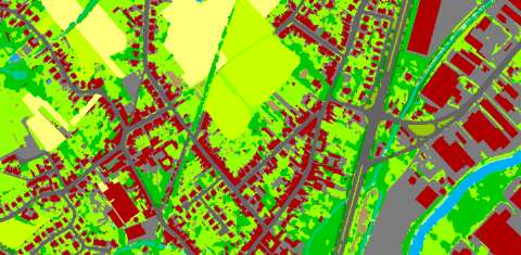
Land management and land planning requires a knowledge of the current state of the landscape. Understanding current land cover and how it is being used, along with an accurate means of monitoring change over time, is vital to any person responsible for land management. Measuring current conditions and how they are changing can be easily achieved through land cover mapping, a process that quantifies current land resources into a series of thematic categories, such as forest, water, and paved surfaces.
By using remotely sensed imagery and semi-automated classification methods, BitsOfData provides cost-effective and accurate means to derive land resource information and maintain its currency into the future.
More current, accurate, and cost-effective methods for gathering information about landscape change have become available to users in the fields of urban planning, land management, and natural resource conservation. BitsOfData offers that can be tailored to meet your project requirements.
The creation of a land cover map is the first step in the generation of easily interpretable infromation in support of the management of urban green, inventarisation of vegetation, monitoring of forest changes, soil impermeability, ...
Application possibilities
Vegetation monitoring
The distribution and monitoring of vegetation, its properties and state, is of major importance for a wide range of applications (agriculture and forestry, environmental management, natural hazard monitoring, ...).
Remote sensing provides the best means to monitor changes in vegetation over a wide range of temporal scales over large areas.

Large area land cover
Monitoring and mapping of land cover and land cover change in a consistent and robust manner over large areas is made possible with Earth Observation (EO) data.
Good land management aims to find the right balance between economic, social and environmental factors, leading to a sustainable urban & regional land use. To achieve this, regional decision makers need land use / land cover information.
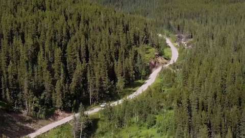
Right-Of-Way
A pipeline/powerline right-of-way is the piece of land over and around an linear infrastructure. The right-of-way isregularly inspected and a clear and unobstructed right-of-way enables to safely operate, patrol, inspect, maintain and repair our pipelines.
This inspection is very labour intensive, time consuming, and therefore costly. An inventory of the right-of-way can be created based on a dedicated land cover mapping proces. A specific set of attributes can be calculated to facilitate the management of the right-of-way.